DriveOSS: Dataset and Benchmark for 3D Anomaly Segmentation and Open-set Semantic Segmentation in Autonomous Driving

Accepted at IEEE/CVF WACV 2027 • Datasets Track
TL;DR: DriveOSS is the first real-world multimodal autonomous driving dataset and benchmark designed to jointly evaluate Closed-Set 3D Semantic Segmentation, 3D Anomaly Segmentation, and 3D Open-Set Semantic Segmentation across 5 weather and lighting conditions (Clear, Night, Cloudy, Rain, Snow).
DriveOSS Overview — 128-Beam LiDAR + 6× Surround RGB
DriveOSS Overview
12,661
Annotated LiDAR Scans
75,966
6-View RGB Images
52
Scenes (19 ID / 33 OOD)
5
Weather Domains
19 + 1
ID Classes + Outlier
1.52M
3D Outlier Points
Motivation & Scope

Abstract

Recent advances in 3D semantic segmentation have significantly improved scene understanding in autonomous driving. However, existing methods are typically developed under a closed-set assumption and evaluated under standard driving conditions, where all categories are known in advance. In real-world driving, autonomous vehicles inevitably encounter previously unseen objects, making closed-set perception insufficient for safe deployment. To address this challenge, we introduce DriveOSS, which, to the best of our knowledge, is the first real-world multimodal dataset and benchmark specifically designed for 3D anomaly segmentation and open-set semantic segmentation. It contains 12,661 synchronized and annotated frames captured using six surround-view RGB cameras, a 128-beam LiDAR, and a GPS/IMU unit. The dataset comprises 52 real-world driving scenes collected under clear, nighttime, cloudy, rainy, and snowy conditions and is organized into ID (in-distribution) and OOD (out-of-distribution) subsets. The ID scenes contain only known classes and are used for training, whereas the OOD scenes additionally contain unknown objects annotated as the outlier class and are used for validation and testing. Extensive experiments show that unseen objects remain a major challenge for current 3D perception systems.
Adverse Weather & Disjoint Splits

Recorded with an Ouster OS1-128 LiDAR (20 Hz), 6 Basler RGB cameras (10 Hz), and RTK-INS (600 Hz) across Clear, Nighttime, Cloudy, Rainy, and Snowy conditions on geographically disjoint ID and OOD routes.

Unified 3D Open-IoU Protocol

Unlike binary anomaly benchmarks that discard background semantics, DriveOSS retains all 19 known ID classes + 1 Outlier class in OOD scenes, enabling joint evaluation via 3D mOpen-IoU.

LiDAR & Multimodal Baselines

Benchmarks P3Former, LCPS-lidar, Mask4Former3D, LIDO, LCPS, and our query-level fusion baseline Mask4Former3D* across MSP, MaxLogit, Energy, Entropy, and RbA scoring.

Literature Context

Comparison with Automotive 3D Datasets

Dataset Year Weather & Illumination Modality #Beam Cameras OOD Scene Annotations Tasks
SemanticKITTI2019Clear onlyL+C64Front× None (Closed-set)SS, PS
Panoptic nuScenes2021DiverseL+C326× Surround× None (Closed-set)PS
SemanticSTF2023Fog / Rain / SnowL+C64Front× None (Closed-set)SS
Panoptic-CUDAL2025RainL+C128Surround× None (Closed-set)PS
STU2025Clear onlyL+C128SurroundBinary (Inlier / Outlier)PS, AS
LIDO (Synthetic Mix)2026Clear onlyL32/40/64—Binary (Inlier / Outlier)AS
DriveOSS (Ours) 2027 Clear, Night, Cloudy, Rain, Snow L+C 128 6× Surround ✓ 19 ID Classes + Outlier SS, AS, OSS
Hardware & Environmental Diversity

Multimodal Sensor Suite & Weather Distribution

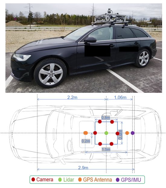
Synchronized Recording Platform

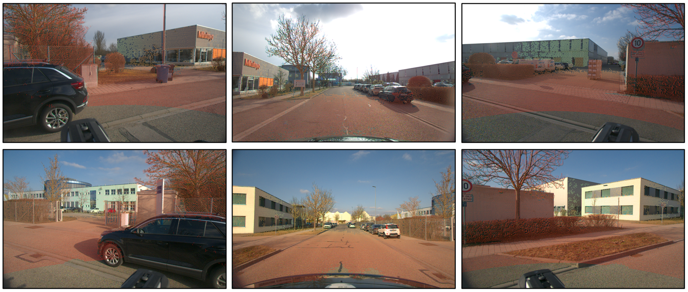
All sensors are hardware-synchronized to a common GPS-derived time reference across urban, rural, downtown, pedestrian, and industrial zones:

  • 1× LiDAR (Ouster OS1-128): 128 beams, 360° H-FOV, −22.5° to +22.5° V-FOV @ 20 Hz.
  • 6× RGB Cameras (Basler ace2R): Surround-view 1920×1080 resolution @ 10 Hz.
  • 1× GNSS/INS (Certus RTK): >600 Hz update rate, 0.01 m horizontal & 0.015 m vertical accuracy.
Data Recording Platform
DriveOSS Sensor Vehicle
Surround LiDAR-Camera Calibration
LiDAR-Camera Calibration

Distribution Across Splits & 5 Weather Domains

Environmental Domain ID Train Split ID Validation Split OOD Validation Split OOD Test Split
Seq. Frames Seq. Frames Seq. Frames OOD Points Seq. Frames OOD Points
Clear 4 809 6 1,701 9 2,315 252,606 8 1,766 885,729
Nighttime 1 184 1 79 2 287 22,132 2 357 42,979
Cloudy 2 636 1 186 2 742 43,548 2 666 71,440
Rainy 1 399 1 165 2 696 35,104 2 618 66,509
Snowy 1 212 1 253 2 238 12,898 2 352 89,803
Overall DriveOSS 9 2,240 10 2,384 17 4,278 366,288 16 3,759 1,156,460
Anomalies & Ground Truth Quality

OOD Hazard Taxonomy & Two-Stage Annotations

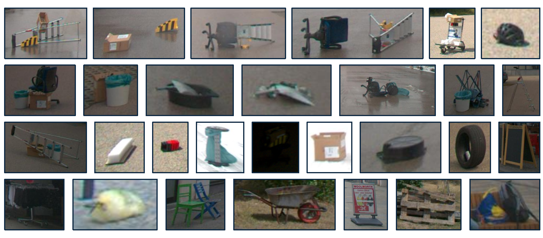
Representative OOD Samples
Representative OOD Objects
📦 1. Containers & Packaging

Cardboard boxes, plastic boxes, foam blocks, garbage bags, and small trash bins with simple geometries and diverse materials.

🪑 2. Furniture & Fixtures

Office chairs, folding chairs, wooden chairs, clothes racks, and advertising signs with complex structures and varying heights.

🪜 3. Tools & Industrial Equipment

Ladders, shovels, metal barriers, and maintenance equipment featuring rigid structures and occasionally high reflectivity.

🎒 4. Personal Belongings

Backpacks, bicycle helmets, bags, and personal items representing small low-profile hazards with irregular shapes.

🛒 5. Utility & Service Equipment

Shopping carts, waste-collection carts, and mobile bins commonly encountered in urban and commercial driving zones.

🪵 6. Roadside Debris & Misc.

Wooden boards, fallen signs, tires, and unstructured obstacles with diverse appearances and physical properties.

Spatial-Hazard Protocol & Annotation Workflow

To maintain an objective boundary between outlier and other-object, any non-ID object located on or immediately adjacent to the drivable surface (road, parking, lane-marking, or sidewalk curb) is strictly annotated as outlier, while permanent off-road fixtures (bus shelters, benches) are labeled other-object.

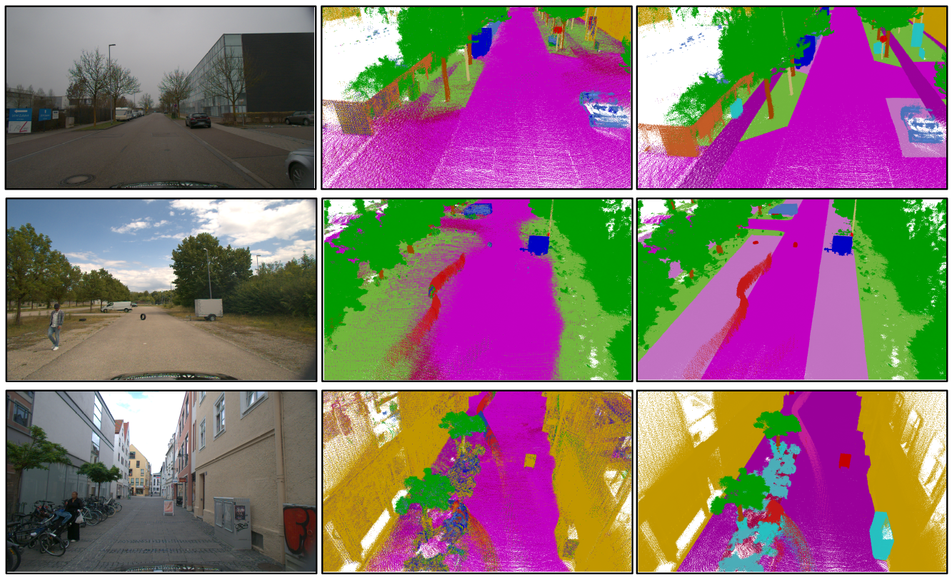
100% of OOD objects are manually annotated from scratch. For ID classes, KISS-ICP registered scans are initialized with coarse Mask4Former pre-labels and thoroughly overhauled via plane removal, class-isolation filtering, and independent dual-annotator verification.

Prelabel vs Refined_GT
Pre-label vs Refined Ground Truth
Quantitative Evaluation

Interactive Benchmark Explorer

Showing the best-performing anomaly scoring variant per architecture across all 19 known classes + Outlier.

Method (Best Variant) Mod. car bicycle motorcycle truck other-veh. person bicyclist motorcyclist road parking sidewalk other-gnd. building fence vegetation trunk terrain pole traffic-sign outlier ↑ mOpen-IoU ↑
P3Former + RbA L 2.130.000.000.000.000.000.000.0016.621.030.510.7265.180.0853.4713.104.490.351.14 1.51 8.36
LCPS-lidar + Entropy L 41.479.791.5311.270.0029.5310.010.0031.510.148.840.0075.3016.5055.065.890.3213.5665.25 0.61 20.75
M4F3D + RbA L 34.9011.118.3911.840.5328.1427.060.0018.8513.4617.870.164.440.262.643.592.430.731.60 0.32 9.58
LIDO (Joint) L 38.777.640.0010.0011.3218.5217.060.0038.7611.9736.270.0293.9762.5678.0813.9621.367.300.16 1.07 22.98
LCPS + Entropy L+C 37.881.943.607.400.2224.6417.500.0026.080.105.760.0477.6026.8840.304.711.678.4945.93 0.57 17.41
M4F3D* + RbA L+C 44.835.304.888.212.4837.8132.960.5217.180.0318.550.6510.492.913.458.867.872.944.20 0.21 11.27
Method (Best Variant per Backbone) Modality AUROC (%) ↑ FPR@95 (%) ↓ AP (%) ↑
P3Former + RbALiDAR89.8045.943.53
LCPS-lidar + EntropyLiDAR79.7646.951.38
Mask4Former3D + RbALiDAR67.91100.0012.57
LIDO (Joint Feature-Based)LiDAR91.7032.664.44
LCPS + EntropyL + C78.6754.441.59
Mask4Former3D* + MSPL + C70.3896.857.11
Method Modality DriveOSS-ID Val mIoU (%) ↑ DriveOSS-OOD Test (ID Points) mIoU (%) ↑ Domain Shift Drop (Δ)
P3FormerLiDAR43.2729.58−13.69
LCPS-lidarLiDAR51.9433.75−18.19
Mask4Former3DLiDAR34.9831.11−3.87
LIDOLiDAR58.3540.99−17.36
LCPSL + C54.0534.00−20.05
Mask4Former3D* (Query Fusion)L + C48.4428.46−19.98
Method Modality Base Network (ms) +MSP +ML +Energy +Entropy +RbA Total Per-Frame Latency ↓
P3FormerLiDAR51.290.070.100.130.100.1151.36 – 51.42 ms (~19.5 FPS)
LIDOLiDAR68.01End-to-End Joint Semantic + Anomaly Branch68.01 ms (~14.7 FPS)
LCPS-lidarLiDAR85.440.120.170.250.190.1885.56 – 85.69 ms
Mask4Former3DLiDAR104.210.110.170.230.180.13104.32 – 104.44 ms
Mask4Former3D* (Query Fusion)L + C106.350.100.160.210.170.12106.45 – 106.56 ms (+2.05% vs L-only)
LCPS (Dense Point-Pixel Fusion)L + C179.800.110.160.210.150.16179.91 – 180.01 ms (+110.4% vs L-only)

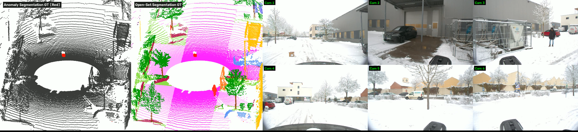
Qualitative Comparison Across Benchmark Tasks

Qualitative Benchmark Comparison
Qualitative Results
citation.bib
@inproceedings{yan2027driveoss,
  title     = {DriveOSS: Dataset and Benchmark for 3D Anomaly Segmentation and Open-set Semantic Segmentation in Autonomous Driving},
  author    = {Yan, Zhiran and Bhanderi, Savankumar and Lolge, Sourabh and Song, Rui and Paneliya, Girdharbhai and Agrawal, Shiva and Elger, Gordon},
  booktitle = {TODO TODO},
  year      = {TODO}
}